Why know the ground before you buy the plot?
A plot is chosen for what you can see: the view, the orientation, the street. The cost of the substructure, though, is decided by what you cannot see. Two plots in the same village can have completely different ground under the topsoil: firm gravel on one, soft clay and water a metre below the surface on the other. The difference shows up in the foundations, the waterproofing and the drainage, the items that cannot be changed cheaply once the concrete is poured.
I describe the full check of a plot in the guide to choosing a plot. This text goes one layer deeper: what a geological survey delivers, how to read soils and water, how radon is measured and when a house is split by a movement joint. Ideally you have the answers before signing the contract. If the seller will not allow that, then at the latest before the first sketch, never after excavation.
A first estimate comes from the geological and radon maps of the state geological service and from asking the neighbours about water in the excavation or cracks. These describe the surroundings, though, not a result for your plot.
What does an engineering-geological survey actually deliver?
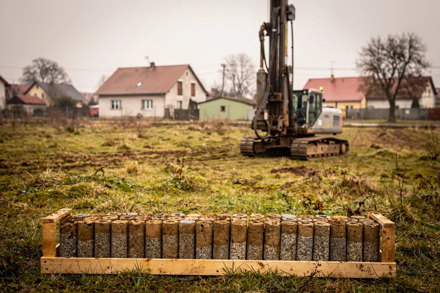
An engineering-geological survey is carried out by a geologist on the plot itself. For a family house this means several probes spread over the footprint of the future house: boreholes from which a soil core is extracted, trial pits dug by an excavator where the layers are visible in the pit wall, and sometimes penetration tests that measure the soil's resistance with depth. The samples go to a laboratory and the result is a report with the probe logs, an evaluation and recommendations for the foundations.
As the designer, I look for four things in the report. The first is the order and thickness of the layers, that is, where the topsoil and made ground end and the undisturbed soil begins. The second is the classification of the soil in each layer, from which the structural engineer reads how it behaves under load and when its moisture changes. The third is the bearing capacity of the soil together with the expected settlement. The fourth is the groundwater level: where the probe struck it, where it settled and what the estimate of its highest level during the year is. A single reading from a dry autumn can lie noticeably lower than the spring level.
| Survey finding | What it changes in the design | Effect on the budget |
|---|---|---|
| Firm, uniform ground, water deep down | Ordinary shallow foundation, protection against soil moisture | The cheapest substructure |
| Firm layer only below made ground or soft soil | Deepened foundations, soil replacement or piles | More excavation and concrete, possibly drilling rigs |
| Clay sensitive to moisture changes | Deeper formation level, stiffer slab, distance from trees | More concrete and reinforcement, more careful details |
| Water level at the level of the planned basement | Watertight substructure, pumping water from the excavation | The biggest jump, often a reason to give up the basement |
Which soils occur in Slovakia and what do they mean for a house?
Slovakia is geologically varied and the types of ground change even over short distances. With family houses I most often meet four situations.
Clays that swell and shrink
In the lowlands and hill country the ground is often clay, which increases in volume when it gets wet and shrinks when it dries out. In a dry summer cracks open in it and the soil under the edge of the house drops, then rises again in autumn. A shallow foundation moves with it. The answer is a formation level below the zone of seasonal moisture change, a stiff slab that bridges the unevenness, rainwater led away from the house and enough distance from mature trees, whose roots dry the clay out.
Made ground
Made ground is soil that somebody brought to the site: a backfilled clay pit, a levelled ravine, rubble from a demolished house. It is unevenly compacted and should not be built on. Either it is replaced with compacted material or the foundations are taken down to undisturbed ground, with thick made ground even on piles. On a plot in a built-up area where something stood before, I assume it is there until a probe proves otherwise.
High groundwater
Near rivers, on floodplains and in the flat south the water is often high and its level fluctuates with the season and with the river level. A house without a basement copes without major complications if the ground floor lies above the highest level. A basement in such water is a separate and expensive task.
Slopes and landslide areas
The north and east of the country have extensive flysch areas, where claystones and sandstones alternate and slopes tend to slide. Cutting into them for a house can upset a balance that held for years. I cover the economics of a slope in the article house on a slope; here it is enough to say that on a slope the survey is a condition of the design, not an extra.
| Type of ground | Main risk for the house | Usual design response |
|---|---|---|
| Swelling clays | Seasonal heave and settlement of the edges, cracks | Deeper formation level, stiff slab, drainage of water, distance from trees |
| Made ground | Uneven settlement | Soil replacement, deeper foundations, piles |
| High groundwater | Uplift, water in the excavation, leaks into the basement | House without a basement or a watertight substructure |
| Flysch slope | Triggering a landslide after cutting into the slope | Detailed survey, drainage, retaining structures |
| Gravels and sands | Small for the foundations, but soil gas passes easily | Shallow foundation, attention to the radon survey result |
Soil moisture, seeping or pressurised water: which waterproofing goes where?
Waterproofing is not designed according to which product is on offer, but according to how water acts on the substructure. Three cases are distinguished and the boundary between them is set by the survey, not by an impression from a site visit.
Soil moisture is water held in the pores of the soil that does not press on the structure. A continuous membrane under the slab and on the walls in contact with the ground is enough. Seeping water is rainwater running down through the soil. In permeable gravel it drains away by itself, but in clay it collects in the backfill around a basement and starts pressing on the wall. Pressurised water acts where the substructure reaches below the groundwater level, or where water collects permanently in impermeable soil.
With pressurised water there are two routes. The first is pressure-water waterproofing, a continuous membrane system around the whole substructure, the so-called black tank. The second is the white tank, in which the concrete itself provides the watertightness. Concrete cannot be poured in one go, though, so the weak points of a white tank are not the walls but the construction joints between pours and the penetrations. Every joint needs a water-stop strip, which, cast into both parts, lengthens the water's path and closes it.
Perimeter drainage is the third tool and the one most often overrated. It helps with seeping water if the collected water has somewhere to drain to. It does not help against pressurised water below the water table, and it is not a means of permanently lowering the groundwater level.
| Water load | When it occurs | Matching protection |
|---|---|---|
| Soil moisture | Permeable ground, water level well below the foundations | Membrane under the slab and on the walls in the ground |
| Seeping water that drains away | Permeable soil without water collecting | Waterproofing as for soil moisture, with a protective layer |
| Seeping water that collects | Low-permeability soil, basement in backfill | Waterproofing designed for pressure, drainage with an outlet |
| Pressurised water | Substructure below the highest groundwater level | White tank with water-stop strips or a black tank, uplift check |
How does a radon survey work and what follows from it?
Radon is a natural radioactive gas that forms in rock and enters buildings from the soil through leaks in the floor. A radon survey of the plot is carried out by a qualified person: at several points within the footprint of the future house they insert probes into the soil to a depth of about 0.8 metres, draw off soil air and measure its radon activity concentration. At the same time they establish the permeability of the soil, that is, how easily the gas moves through it.
The two values give the plot's radon index: low, medium or high. The index is a direct brief for the design. With a low index, carefully executed waterproofing of the structures in contact with the soil, with sealed penetrations, is enough. With a medium index a continuous radon barrier with proven resistance to radon, not only to water, belongs under the whole slab. With a high index a ventilated layer under the slab with passive or active extraction is added to it. After completion radon is measured inside the house, and the reference level for living spaces is 300 becquerels per cubic metre.
Two notes from practice. Gravels and sands, which are excellent ground for foundations, let radon through more easily, so a good geological result does not mean a good radon result. And while a white tank replaces the waterproofing against water, radon protection has to be assessed separately, especially at joints and penetrations.
Slopes and retaining structures: gabions or concrete?
Where the terrain is cut into or built up, it has to be held back. A retaining wall is not a fence: it carries the lateral pressure of the soil and, if drainage is poorly resolved, also the pressure of water that collects behind it.
A gabion wall is an assembly of wire baskets filled with quarry stone. It holds by its own weight, it is permeable, so water passes through instead of pressing on it, and it tolerates slight settlement without cracking. It needs a wide base, though, which means space, and it reads as a stone wall that does not suit every garden. A reinforced concrete wall is slimmer and takes up less of the plot, but it is rigid, needs reinforcement designed by a structural engineer and drainage behind it, otherwise it turns into a dam. For both, the height, foundation and drainage are designed by the structural engineer from the survey, not by the supplier from a catalogue.
Where should a house be split by a movement joint?
Uneven settlement occurs where the ground under the house changes or where the load changes significantly. Typically: only part of the house has a basement, one part stands on rock and the other on clay, a two-storey volume is joined to a light garage, or an extension connects to an old house. A rigid structure will sooner or later tear itself apart at such a point, just not where we would like it to.
A settlement joint divides the house into units that can settle independently. It runs through the full height of the building, foundations included, and it must be drawn before excavation, because it cuts through the waterproofing, the radon layer and the white tank, where it needs its own joint water-stop. Where a joint is missing, cracks take its place.
In what order should you proceed?
- Before buying, look through the public maps and listen to the neighbours.
- Agree access to the plot with the seller and dig at least trial pits, ideally the full survey.
- Order the engineering-geological and radon surveys before the first sketch, not after it.
- Decide on a basement only once you know the highest groundwater level.
- Choose the waterproofing by the water load found and the radon protection by the index.
- Have the movement joints, penetrations and drainage outlet drawn before the excavator arrives.